


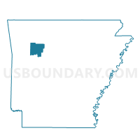
Pittsburg Voting District, Johnson County, Arkansas
About
Outline

Summary
| Unique Area Identifier | 527005 |
| Name | Pittsburg Voting District |
| County | Johnson County |
| State | Arkansas |
| Area (square miles) | 24.87 |
| Land Area (square miles) | 23.01 |
| Water Area (square miles) | 1.86 |
| % of Land Area | 92.52 |
| % of Water Area | 7.48 |
| Latitude of the Internal Point | 35.42040080 |
| Longtitude of the Internal Point | -93.36689590 |
Maps


Graphs
Select a template below for downloading or customizing gragh for Pittsburg Voting District, Johnson County, Arkansas


Neighbors
Neighoring Voting District (by Name) Neighboring Voting District on the Map
- Hickey Voting District, Johnson County, AR
- Howell Voting District, Johnson County, AR
- McKennon Voting District, Johnson County, AR
- Perry Voting District, Johnson County, AR
- Spadra Ward 2, Johnson County, AR
- Spadra Ward 4, Johnson County, AR
Top 10 Neighboring County Subdivision (by Population) Neighboring County Subdivision on the Map
- Spadra township, Johnson County, AR (11,389)
- Pittsburg township, Johnson County, AR (2,466)
- Howell township, Johnson County, AR (1,343)
- McKennon township, Johnson County, AR (944)
- Perry township, Johnson County, AR (787)
- Hickey township, Johnson County, AR (419)